Alkali Hot Springs
GPS: 37.82576579999999,-117.33758369999998
Alkali Hot Spring originally rose from several seeps, but in the early 19th century, Combination Mines Co. drove a 12-m adit to concentrate flow into a single channel. The water was pumped 16 km southeast to the Combination mill at Goldfield. Reed et al. (1983) reported the temperatures of two springs to be 60ºC and 50ºC with flow rates of 223 L/min and 95 L/min, respectively. The adit face measured 60°C .
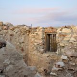
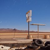
A low dome of gray-brown travertine is present 91 m north of the adit. The spring reportedly contains lithium although Alkali Flat, unlike Clayton Valley (Silver Peak Hot Springs), does not (Albers and Stewart, 1972). The springs were operated by the Joe Guisti family during Goldfield’s heyday, with a large building and indoor swimming pool on site (Rosevear, 1976). Williams (1996, p. 51) referred incorrectly to this spring as Silver Peak Hot Spring. He described a 40ºC pool made of concrete and brick, which locals and visitors use for bathing.
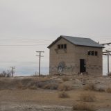
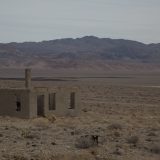
Prior to a NBMG sampling trip in 2008, the most recent geochemistry for Alkali Hot Spring was analyzed in 1957 (R. Mariner Database, USGS, Menlo Park). Mariner calculated a Ca-Na-K, Mg-corrected geothermometer of 135ºC (Fournier, 1981) for Alkali Hot Springs, and a quartz geothermometer of 112ºC. The 2008 sample has not yet been analyzed. NBMG field samplers noted travertine crust along 200m of spring outflow. The upwelling zone is covered with orange algae and juniper bushes, and no detectable sulfur smell. A Goldfield local identified the hot spring source as beneath the defunct powerhouse building, 100m south of the spring. Samplers found major doming of the building foundation, concrete buckled upward, but no access to subsurface water (Penfield et al., 2011). On a return visit on 8/10/2013, a sample of the accessible water at the surface was taken. The temperature of the head water was found to be 50ºC.
More images: